
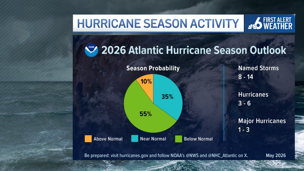
The National Oceanic and Atmospheric Administration released its official outlook for the 2026 Atlantic hurricane season, predicting a 55% chance of a below-average season largely due to the anticipated development of a strong or even “super” El Niño pattern by late summer.
NOAA is forecasting between eight and 14 named storms, with three to six of them becoming strong enough to his hurricane status and one to three of those intensifying to major hurricane levels, which is more than 110 mph. A normal hurricane season typically has about 14 named storms, with seven of them becoming hurricanes and three of them reaching Category 3 or higher.
The Atlantic hurricane season officially runs from June 1 through Nov. 30, with activity typically peaking between mid-August and mid-October, although systems can form outside those dates.

What is El Niño?
El Niño is a climate pattern marked by warmer-than-average water temperatures across the equatorial Pacific Ocean. While it occurs far from the Atlantic Basin, it can have major impacts on tropical development in the Atlantic.
During El Niño years, stronger upper-level winds known as wind shear, typically increase across the Caribbean and tropical Atlantic. That hostile wind environment can disrupt thunderstorms trying to organize into tropical systems, often limiting the number and intensity of storms.
Historically, El Niño years tend to produce fewer named storms, hurricanes, and major hurricanes compared to neutral or La Niña years. However, historically a quieter season does not mean a harmless one.
Major storms still possible during El Niño
Some of the most devastating storms in history have occurred during El Niño years. For example, Hurricane Andrew struck South Florida in 1992 during an El Niño pattern, becoming one of the costliest and most destructive hurricanes ever to hit the state.
More recently, Hurricane Idalia formed during the 2023 El Niño and rapidly intensified before slamming Florida’s Gulf Coast.
It only takes one storm making landfall in a populated area to make a season catastrophic.
What other forecasts have been issued?
Several other groups and academics have also forecasted what they think the season will be like and most of them also call for a below average summer and fall.
Colorado State University, which pioneered the science of hurricane seasonal forecasting in 1984, released its forecast for the 2026 Atlantic hurricane season last month, and also predicted somewhat below-normal activity.
CSU indicated that 13 named storms are expected, six of which would reach hurricane strength, and two that could become major hurricanes.
What will the storms be named in 2026?
For 2026, the National Hurricane Center (NHC) says storms that form in the Atlantic Ocean will have the following names: Arthur, Bertha, Cristobal, Dolly, Edouard, Fay, Gonzalo, Hanna, Isaias, Josephine, Kyle, Leah, Marco, Nana, Omar, Paulett, Rene, Sally, Teddy, Vicky and Wilfred.
What was the 2025 hurricane season like?
Last year’s Atlantic hurricane season brought three Category 5 systems, including one of the most powerful hurricanes ever recorded, but no U.S. landfalls and a lull during the usual peak of activity.
“It was a strange year,” said scientist Phil Klotzbach, who studies hurricanes at Colorado State University. “A hard year to describe.”
In total, five hurricanes formed (Erin, Gabrielle, Humberto, Imelda and Melissa), and four were considered major.


0 Comments